Tuesday, April 30, 2013
A better weather pattern for NJ Metro
Video is from around Noon -- 4/30/2013
The gloomy weather is gone... until?
Some improvement for NJ metro weather today
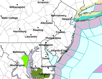
Latest post: 9:45am -- 4/302013
After a wet and chilly Monday, some positive changes in the weather for NJ will be seen today...
There will be a few breaks of sun during the day, and temperatures will be milder -- reaching between 60 and 65 degrees inland, and upper 50s at the coast. A passing shower is still possible (20% chance), particularly for southern New Jersey.
Tonight is expected be partly to mostly cloudy -- with some clearing after midnight. Low temperatures fall into the middle 40s.
Wednesday is forecast to be a much brighter day, with partly to mostly sunny skies. Highs should reach the middle 60s away from the coast, and the upper 50s at the beaches.
Thursday and Friday will see mainly sunny days, and highs around 70 degrees -- a bit cooler at the shore.
For the weekend -- Saturday and Sunday are expected to remain sunny and warm -- with highs topping out between 70 and 75 degrees for all areas.
Original satellite image at the time of this post is from 9:30am -- 4/30/2013
Monday, April 29, 2013
Wet and cooler weather has returned to the Garden state
Wet and cooler for NJ metro to start the new work-week
Mon, 29th April, 2013

Sunday, April 28, 2013
More clouds and then rain to arrive in NJ metro soon
Latest post: 1:30pm - 4/28/2013
After a beautiful Saturday, the second part of the weekend is expected to be very nice as well...
The rest of today will be partly sunny, with more clouds arriving by evening. Rain is not expected during the daylight hours, as highs reach the lower 70s inland, and remaining in the lower 60s at the coast.
Tonight will be mainly cloudy, with temperatures dropping into the upper 40s in the suburbs to the lower 50s for much of NJ and New York City.
Changes in our weather begin on Monday, with mostly cloudy skies. Some rain and drizzle is likely, especially for southern and western NJ. The rain may try to sneak in to NYC and Long Island by late in the afternoon or evening. High temperatures will be much cooler, only reaching the lower 60s inland, and the upper 50s at the shore.
Monday night is expected to remain cloudy will rain and drizzle likely for all areas. Lows only fall into the lower 50s.
Tuesday is expected to see more the gray and cool conditions, with light rain and drizzle continuing, particularly in the morning. Readings will top out once again in the lower 60s inland, and the upper 50s at the coast.
Wednesday should be dry, with more clouds than sun. Temperatures top out between 60 and 65 for inland areas, and upper 50s at the beaches.
Thursday and Friday are likely to be the warmest days of the week, as the sun returns, and highs reach 70 degrees.
Radar image is from 1:30pm -- 4/28/2013
Saturday, April 27, 2013
Double duty -- A nice Sunday rounds out the weekend for NJ metro
Make it a double -- A nice Sunday for NJ metro
Sat, 27th April, 2013
Friday, April 26, 2013
Sunny Friday for NJ metro
Which weekend day will be nicer for NJ metro?
Video is from around 11am -- 4/26/2013
More nice weather to end the week for NJ metro
Latest post: 9:40am -- 4/26/2013
After starting the week chilly and gray, the second half of the week has been much nicer...
Today continues with sunshine, with highs between 65 and 70 degrees.
Tonight will be clear and chilly, with lows dropping to the lower to middle 40s.
The weekend forecast features more of the same...
Saturday will be mostly sunny, with highs again topping out between 65 and 70 degrees.
Sunday starts out with sunshine, with some increase in clouds expected in the afternoon, but it will remain rain-free.
High temperatures over the weekend will generally be in the 60s to around 70, with readings closer to 60 at the shore on Sunday.
The new work-week will see some changes... with the weather not as bright.
Monday, Tuesday and Wednesday will see more clouds than sun, with scattered showers from time-to-time.
Temperatures should top between 60 and 65 inland, and in the upper upper 50s at the coast.
Satellite image is from 9:30am -- 4/26/2013
Thursday, April 25, 2013
Cooler on Thursday for New Jersey metro
Latest post: 11:45am -- 4/25/2013
After a warm day on Wednesday, cooler conditions have arrived today.
Sunshine will fill the skies for the rest of the day along with a brisk breeze. Highs will top out between 60 and 65 degrees.
Tonight will be clear and chilly, with lows dropping into the upper 30s and lower 40s for the NJ/NYC/ Long Island metro area.
To end the week on Friday, mostly sunny conditions are expected to continue, with highs once again in the 60s.
The weekend will feature more of the same, with mostly sunny skies on Saturday, and partly sunny skies for Sunday. Both days will remain with high temperatures in the 60s.
Next week could see some clouds on Monday and Tuesday, with perhaps a shower.
Wednesday should be mainly sunny.
High temperatures should reach the 60s to around 70 degrees.
Satellite image is from 4/25/2013 --11:30am
Wednesday, April 24, 2013
Showers have weakened approaching the Garden state
Latest post: 9:30pm -- 4/24/2013
Weather update: The approaching weather front has weakened....
Therefore, I am lowering rain chances to 40%...
Only a passing, quick shower is expected for the rest of the night..
Radar image is from 9:00pm -- 4/24/2013
Weather update: The approaching weather front has weakened....
Therefore, I am lowering rain chances to 40%...
Only a passing, quick shower is expected for the rest of the night..
Radar image is from 9:00pm -- 4/24/2013
Scattered showers, a thunderstorm, arriving soon in NJ
Radar update:
Clouds are about to arrive...
But rain should hold off until after 8pm...
Radar image is from 5:00pm -- 4/24/2013
Clouds are about to arrive...
But rain should hold off until after 8pm...
Radar image is from 5:00pm -- 4/24/2013
Spring weather has returned for NJ metro
Latest post: 11:00am -- 4/24/2013
The warm weather for this week has finally arrived...
Mostly sunny skies will continue for the late morning into the early afternoon, with highs reaching 70 degrees or above for inland areas, and locations along the shore may be a little cooler, with highs in the mid-60s.
Later this afternoon, more clouds will appear, and northern and western NJ could see a shower or thunderstorm after 5 or 6pm. (30% chance).
Tonight will be cloudy, and all areas are likely to see some showers and a thunderstorm (60% chance). Lows temperatures only drop to between 45 and 50 degrees.
Thursday begins with some clouds, with the sun returning by mid- to late morning. Highs are expected to be a bit cooler, as readings top out between 60 and 65 degrees. Winds will be brisk.
Friday remains on the bright side, along with mild temperatures. High temperatures once again top out in the lower and middle 60s.
The weekend is expected to be mainly sunny and mild.
Enjoy the long-awaited nice weather!
Radar image is from 10:30am -- 4/24/2013
Tuesday, April 23, 2013
Staying chilly for one more day this week for NJ metro
Latest post: 9:45am -- 4/23/2013
Today is expected to be partly to mostly cloudy -- with some light rain possible over Long Island. It remains windy, particularly for NYC and points east. Highs will reach the middle 50s.
Tonight will remain mainly cloudy, with perhaps some light rain on Eastern Long Island once again. Temperatures will drop into the lower to mid- 40s, and upper 40s for NYC.
Wednesday will see improvement -- both in the sky, and with the temperatures. Brighter and warmer conditions are expected, with highs reaching 70 degrees inland, and around 60 degrees for coastal areas.
More clouds arrive in the afternoon, and some showers and a thunderstorm are possible by evening north and west of NYC, and for all areas of NJ/NYC and Long Island Wednesday night.
Lows only fall to around 50 degrees.
Thursday could start off with some clouds, but much of the day is expected to be mainly sunny, with highs between 60 and 65 degrees.
Friday will be mostly sunny, with highs in the low and mid-60s.
The weekend should remain dry and mild.
Radar image is from 9:30am -- 4/23/2013
Monday, April 22, 2013
Cool and Windy on Monday for NJ metro
Latest post: 10:30am -- 4/22/2013
The cool weather from over the weekend continues for the start of the new work-week...
Today will see a mix of sun and clouds -- with more clouds arriving later today, especially on Long Island... Winds continue to be brisk, with gusts over 30mph at times. Highs will reach the middle and upper 50s. Some light rain is possible by evening in southern NJ and Long Island (a 30% chance).
Tonight will be partly to mostly cloudy, with a slight chance of rain, (30% chance once again), particularly on Long Island. It is expected to remain breezy, with lows dropping into the 40s.
On Tuesday, a storm will be coming up the East coast...
The weather models are in better agreement today, tracking the storm far enough out to sea to keep the day dry, with perhaps a bit of light rain for Long Island (30% probability). Highs will not change much -- topping out in the 50s for one more day.
The warm-up arrives on Wednesday, as the wind direction shifts to the south -- resulting in temperatures reaching the middle and upper 60s for areas away from coast. Skies should be partly sunny.
Some showers and a thunderstorm will move in Wednesday evening or Wednesday night, as readings only drop to around 50 degrees.
Thursday will be cooler -- but Friday will be milder again. Both days should remain dry at this point.
Radar image is from 4/22/2013 -- 10:15am
Sunday, April 21, 2013
Cold weather gardening tip
Just another reminder to bring in or cover any new or newly-planted flowers, as they may be sensitive to the continued cold night-time temperatures.
Another cold and possibly frosty night for NJ metro
Frost advisories in effect again for parts of NJ and Long Island...
Saturday, April 20, 2013
Freeze advisories for parts of Long Island and New York state
Some freezing temps for NY metro
8:30am - 4/21/13 update:
All frost and freeze and advisories have been lifted, as these conditions are no longer expected.
8:30am - 4/21/13 update:
All frost and freeze and advisories have been lifted, as these conditions are no longer expected.
Cold for NJ tonight
Find out if your NJ county may see frost early on Sunday morning...
Frosty Sunday morning?
8:30am - 4/21/13 update:
All frost and freeze and advisories have been lifted, as these conditions are no longer expected.
Frosty Sunday morning?
8:30am - 4/21/13 update:
All frost and freeze and advisories have been lifted, as these conditions are no longer expected.
A chilly weekend for NJ metro
Latest post: 10:10:am -- 4/20/2013
After summer-like weather with temperatures in the 70s on Friday, the start of the weekend will be the beginning of cooler weather for the NJ metropolitan area.
Today will be see highs struggle to reach 60 degrees, but gusty winds will make feel more like the lower 50s. Skies will be mostly sunny for the afternoon.
Tonight will be clear and cold with diminishing winds. Temperatures will drop all the way down into the 30s, with some upper 20s possible for northern and western sections of NJ as well as parts of Long Island.
**Many plants or flowers can be sensitive to these colder conditions...
It is recommended to take them indoors, or cover them if you are able to.**
Tomorrow will become breezy once again, with sunny skies, with high temperatures only topping out in the middle 50s.
The first half of the new work-week will not see an end to the chilly weather. Mornings will be in the 40s, with highs in the upper 50s and lower 60s. Some rain is possible Monday night or Tuesday.
Radar image is from 9:30am -- 4/20/2013
Weather tip
Temperatures overnight tonight will drop down close to 40 degrees for much of NJ/NYC and Long Island -- and by wake-up on Sunday, readings will be in the lower and middle 30s....
Many plants or flowers can be sensitive to these colder conditions...
It is recommended to take them indoors, or cover them if you are able to.
Thunderstorm on Eastern Long Island
A severe thunderstorm warning is in effect for Eastern Long Island...
Friday, April 19, 2013
Some heavy rain overnight for NJ metro
I am thinking that the severe threat has ended for NJ/NYC and Long Island has ended. Any storms can still have heavy downpours and gusty winds.
Rain update for NJ metro
Radar update: The first line of showers has weekend a bit --
The main line of showers and heavy thunderstorms is also now forecasted to be delayed by about 1 hours for all areas...
So -- for NJ between 8:30pm and 9:30pm -- west to east...
For NYC between 9:30pm and 10pm...
And for Long Island between 10:30pm and 11:30pm..
Severe weather will continue to be monitored from these storms...
Original radar is from 6:45pm -- 4/19/2013
Severe weather in Pennsylvania moving east ...
Weather update: Just wanted to pass along some detail on this next weather front....
In Pennsylvania, a Tornado Watch has been issued...
If thunderstorms hold together in a severe fashion when they cross into New Jersey, a watch may be issued for our area as well.
Additional posts will be updated as necessary.
Radar image as of this post is from 4:45pm -- 4/19/2013
Rain arrives later today for NJ metro
Latest post: 9:15am -- 4/19/2013
Today will see some breaks in the clouds, along with warmer temperatures. Highs will reach 70 degrees for some areas in New Jersey away from the coast, with upper 50s to around 60 for locations along the shore. A scattered shower or two is also possible. Winds will be brisk.
Rain arrives this evening around 7pm for NJ, 8pm for NYC and around 9pm for LongI Island.
Tonight will windy conditions along with showers and thunderstorms for all areas -- with heavy rain likely and some flooding in poor-drainage areas possible. Temperatures will only fall into the lower and middle 50s for the metropolitan area.
The wind will gust over 30mph at times.
This weather front is expected to clear the area early Saturday morning -- with some showers on eastern Long Island ending around 8am -- and all areas seeing the sun returning between 8am and 10am. It will remain breezy, with high temperatures around 60 degrees.
** Sunday will see a quick cold snap in the morning, with temperatures in the 30s for many areas in NJ, including Long Island and NYC. **
The rest of Sunday will be sunny, breezy and cool, with highs only in the middle 50s.
The new work-week will start off with some chilly morning temperatures in the upper 30s and lower 40s for Monday and Tuesday ... and day-time highs in the upper 50s and lowers 60s.
Each day is will see partly sunny skies, and should remain dry.
Radar image below with this post is from 9:00am - 4/19/2013
A winter chill possible for part of the weekend
Some areas in NJ and Long Island may see temperatures in the 30s early Sunday morning...
Thursday, April 18, 2013
Cooler for NJ metro today
Latest post: 9:00am -- 4/18/2013
Today will feature lots of clouds -- perhaps a peek of sun. Temperatures will be cooler than Wednesday, with highs in the mid-60s away from the shore, and upper 50s at the beaches. There will be a brisk breeze at times. A shower is also possible in the afternoon.
Tonight is expected to remain cloudy, along with some drizzle and areas of fog. Temperatures will not fall too much, dropping only to the lower 50s for most areas.
Friday turns milder, with more clouds than sun once again. Some drizzle and areas of fog are possible in the morning. Much of the day is expected to be dry, with afternoon highs reaching 70 degrees inland again and upper 50s along the coast.
Showers and thunderstorms are expected wait to arrive until the evening hours -- around 7pm for New Jersey, 7:30pm for NYC and close to 9pm for Long Island.
Friday night will see heavy rain continuing, with some thunderstorms as well, and it will become windy. Temperatures will drop into the 50s.
This weather front will clear the area by the weekend, with Saturday starting off with some clouds, and the sun returning by mid- to late morning. Cooler and breezy conditions move in for the afternoon. Highs will top out in the upper 50s.
Sunday will be sunny and breezy, with highs in the mid- to upper 50s.
The start of the new work-week will be cool and dry...
Radar image with this post is from 8:45am -- 4/18/2013
Wednesday, April 17, 2013
Not as nice on Thursday for NJ metro
Weather update: Tomorrow will not be as warm as today, with little to no sun on Thursday.
Friday will be milder again, with some sun possible.
** Heavy rain looks to arrive between 8pm and 10pm Friday night for much of the NJ/NYC/ Long Island area... closer to 10pm for Long Island **
Radar image below with this post is from 7:45pm -- 4/17/2013
Updates on this heavy rain threat will be posted again on Thursday...
Clouds breaking for the sun today in New Jersey
Latest post: 9:00am -- 4/17/2013
Clouds will continue to break across the rest of the Garden state this morning, and sunshine is expected to dominate for the rest of the day. Temperatures should reach 70 degrees away from the coast, with upper 50s to around 60 degree reading at the shore.
Tonight will be clear early on, with clouds increasing overnight. Low temperatures will drop mainly in the upper 40s and lower 50s.
Thursday is expected to be cooler, with more clouds than sun. A shower is possible in the afternoon. Highs will top out in the mid-60s inland to the upper 50s at the beaches.
Thursday night will be cloudy, with drizzle and areas of fog around. Lows will only drop into the low to mid- 50s across the entire area.
Friday will be warmer again, but skies are expected to be mainly cloudy, with a few peeks of sun possible. Showers will move in late in the day -- after 5pm -- High temperatures will reach 70 degrees away from the coast, with upper 50s expected along the shore.
Friday night will see heavy rain, with thunderstorms as well, as temperatures only drop off slightly, into the upper 50s.
The weekend will start of with some showers very early Saturday morning (ending around 7am )-- with sun for late morning. It will be windy, with temperatures falling from the upper 50s into the mid-50s in the afternoon.
Sunday looks bright and breezy, with highs mostly in the 50s to around 60 degrees.
Satellite image with this post is from 9:00am -- 4/17/2013
Tuesday, April 16, 2013
Some showers possible overnight for NJ metro
An area of showers, along with a rumble of thunder is possible between 3am and 5am for NJ and NYC, and between 4am and 6am for Long Island.
More sun expected again on Wednesday for NJ metro
Latest post: 6:00pm -- 4/16/2013
Some clouds will be around this evening, with a sprinkle or a shower possible... this a 30% chance.
Tonight will be mild, with mainly cloudy skies. Scattered showers will be around ... with this chance highest for northern and western sections of the Garden state. Lows will generally be in 50s.
Wednesday will start out with some clouds in the early morning, with mainly sunny skies expected for the rest of the day. Temperatures will be warm, as highs top out in the lower 70s for inland areas, with upper 50s to around 60 degrees at the coast.
Thursday will be see a mix of clouds and sun, with portions of the day remaining cloudy for a time... Highs will be in the upper 60s to around 70 degrees inland, and 50s at the shore.
Friday will once again see a mix of clouds and sun early in the day-- with the afternoon turning cloudy. Rain is likely by evening. Highs will top out around 70 away from the coast, with upper 50s for shore areas.
Heavy rain will move in during the overnight hours... with thunderstorms possible as well.
This weather system will hopefully clear the area by early Saturday, with high temperatures reaching the upper 50s both days.
Radar image as of this post: 5:30pm -- 4/16/2013
Warmer today for the Garden state
Latest post: 9:25am -- 4/16/2013
After a nice weekend, and a milder Monday, temperatures are expected to warm up for the remainder of the week.
Mostly sunny skies are are seen as of this post this morning, and readings are already in the 50s...
More clouds will fill the sky this afternoon, as temperatures reach the mid- and upper 60s away from the shore, with cooler highs at the beaches. A few showers may arrive late this evening, particularly for northern and western New Jersey. This is a 30% chance.
Tonight will be mild, with mainly cloudy skies. Scattered showers will be around ... with this chance highest for northern and western sections of the Garden state. Lows will generally be in 50s.
Wednesday will start out with some clouds in the early morning, with sunny skies expected for the rest of the day. Temperatures will be warm, as highs top out in the lower 70s for inland areas, and upper 50s at the coast.
Thursday will be see a mix of clouds and sun, with portions of the day remaining cloudy for a time... Highs will be in the upper 60s inland, and 50s at the shore.
Friday will once again see a mix of clouds and sun -- with the afternoon and evening turning cloudy. Rain is likely by evening. Highs will top out around 70 away from the coast, with upper 50s for shore areas.
Heavy rain will move in during the overnight hours... with thunderstorms possible as well.
This weather system will hopefully clear the area by the weekend, with high temperatures reaching the 50s on Saturday and Sunday.
Radar image with his post is from 9:00am - 4/16/2013
Monday, April 15, 2013
Some light rain briefly affecting southern NJ
Just a bit of light rain for southern NJ can be expected over the next hour or so...
Radar image is from 9:30am -- 4/15/2013
Radar image is from 9:30am -- 4/15/2013
NJ weather forecast
Check out a more detailed forecast on my website...Gil Rozett's weather forecast
Clouds and Sun expected for the Garden state this week
Latest post: 4/15/2013 -- 9:30am
** This will be a quick post. A more detailed post will be done later today **
Overall, each afternoon this week is expected to see some sunshine. There will be times
when clouds will dominate, but breaks in the clouds are excepted. High temperatures will mainly be in the 60s away from the coast, with 50s along the shore.
Nights will be partly cloudy, with lows generally in the 40s.
A few showers are possible Tuesday evening, and then again Thursday evening...
The best chance for significant rain will come Friday evening and Friday night.
This weather front should clear by next weekend, with cooler highs in the 50s.
Satellite Image is from 9:00am -- 4/15/2013
** This will be a quick post. A more detailed post will be done later today **
Overall, each afternoon this week is expected to see some sunshine. There will be times
Nights will be partly cloudy, with lows generally in the 40s.
A few showers are possible Tuesday evening, and then again Thursday evening...
The best chance for significant rain will come Friday evening and Friday night.
This weather front should clear by next weekend, with cooler highs in the 50s.
Satellite Image is from 9:00am -- 4/15/2013
Sunday, April 14, 2013
Sunshine on Sunday for NJ metro
Latest post: 9:30am -- 4/14/2013
After a nice Saturday, the second half of the weekend will be even better, with mild temperatures.
Today will be sunny, with light winds, and highs in the upper 50s and lower 60s.
Tonight will be partly cloudy and chilly -- with lows dropping into the upper 30s and lower 40s.
Much of the new work-week will see even warmer temperatures, with a mix of clouds and sun. Some periods may be be cloudy for a time -- and a few showers are possible later Tuesday, and again later Thursday. The best chance of rain looks to arrive Friday evening or Friday night.
High temperatures through this week are expected to be in the 60s, with somewhat cooler readings along the shore.
Radar image with this post is from 9:15am -- 4/14/2013
Friday, April 12, 2013
Another chance of rain for NJ
A line of showers and thunderstorms will be moving through central and southern NJ over the next hour or so. Some will contain heavy downpours, gusty winds, and frequent lightning.
A rainy way to end the week for NJ metro...
Latest post: 9:00am -- 4/12/2013
After a summer-like start to the work-week in the 80s for much of the area, the end of the week has turned wetter and much cooler...
Today will see wet weather for much of the day, with the heaviest rain occurring this morning...
Temperatures will struggle to reach 50 degrees in many locations across the NJ/NYC metro area...Winds will be gusting between 30 and 40mph, producing wind-chill readings in the 30s.
Tonight is expected to turn out partly cloudy, with lows dropping into the 40s. Winds will be lighter.
The weekend overall will be much nicer, with Sunday being the brighter of the two days, with highs in the 50s.
Saturday may still have some clouds around, with perhaps a shower in spots for the afternoon. Temperatures will top out between 55 and 60 degrees.
The start of next week is expected to turn warmer, with highs in the 60s, with some rain returning by around Wednesday.
Radar image with this post is from: 8:45am -- 4/12/2013
Thursday, April 11, 2013
Much cooler for NJ metro today
Latest post: 8:40am - 4/11/2013
After three summer-like days -- temperatures have dropped 25-30 degrees since yesterday -- as the first of two weather systems affecting has moved through the area..
This first weather system will keep temperatures in the 50s today -- with mainly cloudy skies and a brisk breeze. Some sprinkles or drizzle is possible in the afternoon.
During tonight, a second weather front will be approaching, with light rain and drizzle developing early tonight, continuing overnight -- and then a soaking rain arriving by the rush hour on Friday morning. Gusty winds will also accompany this storm -- with the heavy rain continuing through the morning. The rain will lessen in intensity to a more showery nature for the afternoon.
Temperatures will only top out in the low to mid-50s.
The weekend looks better...
Saturday will see partly to mostly cloudy skies, with a passing shower or two possible.
Sunday expected to be brighter.
Both days should see highs between 55 and 60 degrees.
Radar image with this post is from 4/11/2013 -- 8:30am
Wednesday, April 10, 2013
Rain moving in to NW New Jersey
Radar update:
Showers and thunderstorms about to move into NW New Jersey --
NYC and Long Island is next -- within the hour...
NYC and Long Island is next -- within the hour...
Wet weather arriving shortly in New Jersey
Radar update: A couple of showers have formed over NW New Jersey...
These are generally light in nature...
The main line will begin to move into NJ first around 7pm, then into NYC around 7:30, and the rest of Long Island between 7:30 and 8pm...
These storms will produce heavy rain, gusty winds, and some frequent lightning...
Temperatures have been dropping slowly throughout the day, and this will be trend tonight and tomorrow --
Highs tomorrow staying only in the f-f-50s! Br-r-r-r!
Radar image with this post is from 4:15pm -- 4/10/2013
Rain and cooler weather soon to arrive in New Jersey
Summer-like weather is coming to an end - when?
Not as bright or as warm for parts of NJ metro today
Not as bright or as warm for parts of NJ metro today
Wed, 10th April, 2013
Tuesday, April 9, 2013
Weather front will likely keep NJ metro cooler Wednesday
Latest update: 4/9/2013 -- 5:40pm
Weather update: Temperatures were "the balm"(y) today -- with readings between 80-85 for much of the area...
Temperatures are likely to be a little cooler tomorrow if a weather front is close enough to the area to give us more clouds, and maybe even a few afternoon showers... This is especially true for northern NJ/ NYC and Long Island...
If this weather system stays farther north than anticipated, most of NJ/NYC/ Long Island will see more sun, and 80+ highs once again away from the coast, and the showers would stay away...
Let's pray...
More updates as they are needed.
Warm weather again for the Garden state
Video is from around 10:30am -- 4/9/2013
How long will the warm weather last?
Summer-like weather continues for NJ metro today
Another beautiful day for New Jersey metro today
Tue, 9th April, 2013
Subscribe to:
Posts (Atom)