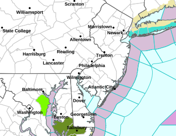
Latest post: 11am -- 11/1/2013
Weather update:
The severe weather threat has all but ended -- perhaps and isolated chance for Long Island for the next 30 - 60 minutes or so.
Some light showers will continue for New Jersey until 1pm, and for NYC and Long Island until around 2pm.
Winds remain gusty through the day.
Friday, November 1, 2013
Much of the Garden state under a severe thunderstorm warning
BULLETIN - EAS ACTIVATION REQUESTED SEVERE THUNDERSTORM WARNING NATIONAL WEATHER SERVICE MOUNT HOLLY NJ 911 AM EDT FRI NOV 1 2013 THE NATIONAL WEATHER SERVICE IN MOUNT HOLLY NJ HAS ISSUED A * SEVERE THUNDERSTORM WARNING FOR...
CAMDEN COUNTY IN SOUTHERN NEW JERSEY... EASTERN MERCER COUNTY IN CENTRAL NEW JERSEY... SOUTHEASTERN SOMERSET COUNTY IN NORTHERN NEW JERSEY... SOUTHEASTERN BUCKS COUNTY IN SOUTHEAST PENNSYLVANIA... SOUTHERN PHILADELPHIA COUNTY IN SOUTHEAST PENNSYLVANIA... GLOUCESTER COUNTY IN SOUTHERN NEW JERSEY... MIDDLESEX COUNTY IN NORTHERN NEW JERSEY... BURLINGTON COUNTY IN SOUTHERN NEW JERSEY... MONMOUTH COUNTY IN CENTRAL NEW JERSEY... NORTHERN ATLANTIC COUNTY IN SOUTHERN NEW JERSEY... OCEAN COUNTY IN SOUTHERN NEW JERSEY... NORTHERN SALEM COUNTY IN SOUTHERN NEW JERSEY... * UNTIL 1030 AM EDT * AT 905 AM EDT...COUNTY OFFICIALS REPORTED A LINE OF HEAVY SHOWERS AND ISOLATED THUNDERSTORMS. THIS LINE EXTENDED FROM HIGHLAND LAKE TO HIGH BRIDGE TO DOYLESTOWN TO KING OF PRUSSIA TO PIKE CREEK...MOVING EAST AT 50 MPH. THIS LINE HAS A HISTORY OF PRODUCING AREAS OF DAMAGING WINDS IN EXCESS OF 60 MPH. THERE IS LITTLE TO NO LIGHTNING BEING DETECTED WITH THIS LINE, HOWEVER VERY STRONG WINDS JUST ABOVE THE SURFACE ARE MIXING DOWN WITH THE LINE AS IT MOVES THROUGH RESULTING IN AREAS OF WIND DAMAGE.
Expansion of severe thunderstorm watch for NJ
Additional New Jersey counties now included in severe thunderstorm watch until 12 noon.
IN CENTRAL NEW JERSEY
MONMOUTH
IN NORTHERN NEW JERSEY
MIDDLESEX
IN SOUTHERN NEW JERSEY
ATLANTIC BURLINGTON CAMDEN
CUMBERLAND GLOUCESTER OCEAN
SALEM
IN CENTRAL NEW JERSEY
MONMOUTH
IN NORTHERN NEW JERSEY
MIDDLESEX
IN SOUTHERN NEW JERSEY
ATLANTIC BURLINGTON CAMDEN
CUMBERLAND GLOUCESTER OCEAN
SALEM
New weather alerts for parts of New Jersey
THE NATIONAL WEATHER SERVICE IN MOUNT HOLLY NJ HAS ISSUED A * SEVERE THUNDERSTORM WARNING FOR... WARREN COUNTY IN NORTHWEST NEW JERSEY... HUNTERDON COUNTY IN NORTHWEST NEW JERSEY... WESTERN MERCER COUNTY IN CENTRAL NEW JERSEY... MORRIS COUNTY IN NORTHERN NEW JERSEY... SOMERSET COUNTY IN NORTHERN NEW JERSEY... SOUTHERN SUSSEX COUNTY IN NORTHWEST NEW JERSEY... BUCKS COUNTY IN SOUTHEAST PENNSYLVANIA... MONTGOMERY COUNTY IN SOUTHEAST PENNSYLVANIA... PHILADELPHIA COUNTY IN SOUTHEAST PENNSYLVANIA... DELAWARE COUNTY IN SOUTHEAST PENNSYLVANIA... NORTHERN NEW CASTLE COUNTY IN NORTHERN DELAWARE... CHESTER COUNTY IN SOUTHEAST PENNSYLVANIA... * UNTIL 945 AM EDT * AT 832 AM EDT...NATIONAL WEATHER SERVICE DOPPLER RADAR INDICATED A LINE OF HEAVY SHOWERS AND ISOLATED THUNDERSTORMS. THIS LINE EXTENDED FROM HIDDEN LAKE TO LEHIGH UNIVERSITY TO GREEN LANE TO HONEY BROOK TO GLEN ROY...MOVING EAST AT 50 MPH. THIS LINE IS CAPABLE OF PRODUCING DAMAGING WINDS IN EXCESS OF 60 MPH. THERE IS LITTLE TO NO LIGHTNING BEING DETECTED WITH THIS LINE, HOWEVER VERY STRONG WINDS JUST ABOVE THE SURFACE CAN MIX DOWN WITH THE LINE AS IT MOVES THROUGH RESULTING IN WIND DAMAGE.
Cold front to cross the area shortly
The worst of the wet weather will be from 9am for northwestern NJ and 10am for much of the rest of the Garden state, when some severe thunderstorms are possible.
Lingering showers can be expected until around 1pm.
Updates on warnings will be posted as necessary.
Lingering showers can be expected until around 1pm.
Updates on warnings will be posted as necessary.
Important weather alerts for NJ/NYC/Long Island
Weather update:
Wind advisory for all of New Jersey, NYC and Long Island until 2pm.
Severe thunderstorm watch for western and northwestern New Jersey until 2pm.
Wind advisory for all of New Jersey, NYC and Long Island until 2pm.
Severe thunderstorm watch for western and northwestern New Jersey until 2pm.
Alerts for New Jersey
Wind advisory to now include northeastern NJ from 4am to 4pm Friday.
Bergen, Passaic, Essex, Union and Hudson counties are under this advisory for wind gusts to possibly reach 50mph during the above time frame
Subscribe to:
Posts (Atom)